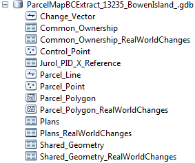
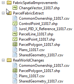
The following table contains mappings between logical names and physical entity names.
| Logical Name | Geodatabase Name & Type (Parcel Fabric Extract) | Geodatabase Name & Type (Real-World Changes) | Shapefile Name | CSV File Name |
| Parcel Polygon Feature | Parcel_Polygon (Feature Class) | Parcel_Polygon_ RealWorldChanges (Feature Class) | ParcelPolygon_ {orderID} | |
| Parcel Line (Resolved) Features | Parcel_Line (Feature Class) | ParcelLine_ {orderID} | ||
| Parcel Point Feature | Parcel_Point (Feature Class) | ParcelPoint_ {orderID} | ||
| Control Point Feature | Control_Point (Feature Class) | ControlPoint_ _{orderID} | ||
| Shared Geometry Table | Shared_ Geometry (Table) | Shared_Geometry_ RealWorldChanges (Table) | SharedGeometry_ {orderID} | |
| Common Ownership Table | Common_ Ownership (Table) | Common_Ownership_ RealWorldChanges (Table) | CommonOwnership_ {orderID} | |
| PID to JUROL Table | Jurol_PID_ X_Referenc (Table) | Jurol_PID_ X_Reference_ {orderID} | ||
| Plan Table | Plans (Table) | Plans_ RealWorldChange (Table) | Plans_{orderID} | |
| Change Vector (Line) Feature | Change_Vector (Feature Class) | ChangeVector_ {orderID} | ||
The Parcel Fabric Extract Product is available in ESRI File Geodatabase and Shapefile Formats.

Shapefile Format
