The three Designation fields in ParcelMap BC are used to break down / summarize the survey divisions in the legal description of the parcel used to uniquely identify the location of the parcel in the context of the survey system in use.
Please see Crown Lands: A History of Survey Systems (W.A. Taylor BCLS) for an overview of the evolution of the survey systems in use in British Columbia.
The Designation fields are often used to apply a label to a parcel on a map or plan to help identify each parcel’s unique survey designation.
The following table provides a definition of the three Designation fields available for Parcel features including an overview of the expected portion of the legal description that will be populated in each of the three fields.
| Survey Division | |||
| Field | Definition | Subdivided | Unsubdivided |
| Designation 1 | The smallest division of lands in the legal description of the parcel. | Parcel or Lot | Quadrant or Block |
| Designation 2 | The second smallest division of lands in the legal description of the parcel. | Block | District Lot or Section |
| Designation 3 | The third smallest division of lands in the legal description of the parcel. | District Lot or Section | Township and/or Range |
How are the Designation 1, 2 and 3 fields populated for parcels that are titled (have a PID)?
Parcel records in ParcelMap BC that have an active title registration (i.e. a PID) are populated via an automated script that translates the values from the short legal fields recorded in the land title register and populates the three Designation fields accordingly.
The short legal description is recorded in the land title register as a series of 13 fields used to parse the legal description based on rules derived from the survey system and whether the parcel is subdivided or unsubdivided. For more information, see Entering Short Legal Descriptions from the myLTSA Help documentation.
For myLTSA users (Enterprise or Explorer), the short legal fields for a titled parcel can be viewed via the “Parcel Information and Miscellaneous Notes” area available in both the ParcelMap BC Search Service and the Search Titles functionality.
The short legal description is made up of a number of fields separated by slashes and generally read from right to left when interpreting the smallest to largest survey division of the full legal description.
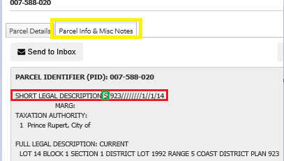
Example 1: Using the ParcelMap BC Search Service, a search for PID 007-588-020 returns a Search Result for the parcel and by selecting the “View Details” option and clicking the Parcel Info & Misc Notes (see highlighted tab in Image 1), the short legal is visible.

In this example, the parcel is subdivided (notice the “S” highlighted in green), therefore the designation fields are populated as follows:
Legal Description: LOT 14 BLOCK 1 SECTION 1 DISTRICT LOT 1992 RANGE 5 COAST DISTRICT PLAN 923
Short Legal Description: S/923////////1//1/14
| Designation 1: Lot 14 | Smallest survey division |
| Designation 2: Block 1 | 2nd smallest survey division |
| Designation 3: Section 1 | 3rd smallest survey division |
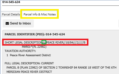
Example 2: PID 014-545-624 is an unsubdivided parcel (notice the “U” highlighted in green)

Following a similar pattern for capturing the 1st, 2nd and 3rd smallest survey divisions in the subdivided parcel example, the designation fields are populated as follows:
Legal Description: PARCEL B (PLAN 22982) OF SECTION 2 TOWNSHIP 84 RANGE 18 WEST OF THE 6TH MERIDIANPEACE RIVER DISTRICT
Short Legal Description: U/PEACE RIVER///18/84///2/////B
| Designation 1: B | Smallest survey division |
| Designation 2: 2 | 2nd smallest survey division |
| Designation 3: 84,18 | 3rd smallest survey division |
Both the Township and Range values are required to uniquely identify the 3rd smallest survey division in this survey system.
In both examples, the full legal description clarifies the values in the Designation fields.
How are the Designation 1, 2 and 3 fields populated for parcels that are not titled (record does not have a PID) but has a PIN?
Parcel records in ParcelMap BC that do not have an active title (record does not have a PID) are populated by the ParcelMap BC Operations team during the update of the parcel fabric (normally as driven by a legal survey plan)based on a set of rules tied to the parcel legal description and survey system. The parcel class and parcel type help determine how the Designation fields are populated from the legal description for parcel records that are not titled.
The short legal description does not apply for parcel records that are not in the land title register.
The following table highlights the rules used to populate the Designation 1, 2 and 3 fields with examples.
| Parcel Class | ||||||||||||||||||||||||||
|
||||||||||||||||||||||||||
|
||||||||||||||||||||||||||
|
(Single Parent Primary) |
|
|||||||||||||||||||||||||
(Multiple Parent Primaries) |
|
For active Crown SRW parcels with Name = SRW and have an active PIN attribute value, the Designation 1 field will be populated with “Area 1” or “Area A” as shown on plan. If there is no Area indicated on plan, the Designation 1 field will be left blank.
How are the Designation 1, 2 and 3 fields populated for parcels that are not titled (record does not have a PID) nor a PIN?
Parcel records that have neither a PID nor a PIN attribute value such as Parcel Class = Park or Parcel Class = Road will not have values populated for the Designation fields.
For parcels with Name = SRW and have neither a PID nor a PIN attribute value, the Designation 1 field will be populated with “Area 1” or “Area A” as shown on plan. If there is no Area indicated on plan, the Designation 1 field will be left blank.