You may search parcels in ParcelMap BC Search for Land Surveyors by text input, through defining an area of interest by shape or by clicking on the map.
Press and hold the CTRL key while clicking a parcel to select it on the map.
Search Parcels by Text Input
From any page of the LTSA's Electronic Services, rollover Searches in the navigation bar and click ParcelMap BC Search
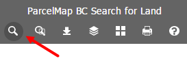
Click the Search Parcels icon
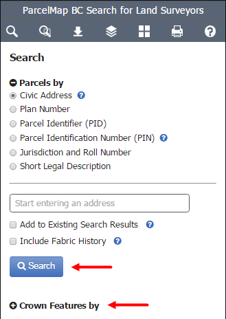
Click Parcels by or Crown Features by
Enter the required information. Available methods to search are:
- Civic Address: The expected format is Civic Number Street Name, Locality Name, Province (e.g. 501 Belleville St, Victoria BC). The field will suggest matches as you type in an address. Select the desired address from the list.
- Plan Number: Include any relevant prefix of suffix (e.g., VAS12345)
- Parcel Identifier (PID): Can be entered with dashes (nnn-nnn-nnn) (eg. 000-000-019) or without. Leading zeros are also optional.
- Parcel Identification Number (PIN)
- Jurisdiction and Roll Number: Can contain dashes, spaces or periods, all of which are optional when searching
- Short Legal Description: Use the Short Legal Wizard to build the correct formatting for this field
Available methods to search for Crown Features are:
- Parcel Identification Number (PIN)
- Plan Number: Include any relevant prefix or suffix. This option quieries the Plan Number and supports a wildard (%) anywhere in the search string. e.g., "EPC%356" could return "EPC356" and "EPC24356". By default, "11TR6" could return "11TR6" and "11TR61".
- Survey Parcel: This option is a freeform search of the Survey Parcel Description supporting a wildcard (%) anywhere in the search string. e.g., “I.R.%3” could return “I.R. NO. 3, BEING SWITSEMALPH, KDYD” and “I.R. NO. 3A, BEING PAVILION, KDYD”. By default, “BLOCK 3” could return “BLOCK 3”, “BLOCK 308” and “SECTION 2, BLOCK 3 NORTH, RANGE 7 WEST”.
Click Search
If the parcel is located, the map will zoom and pan to it and results will be displayed on the Search Results pane on the right hand side. From the Search Results panel, you can view parcel, survey control, and crown feature details, search titles, order plans, zoom to parcels, clear results and navigate to external services for related information. See Manage Search Results.
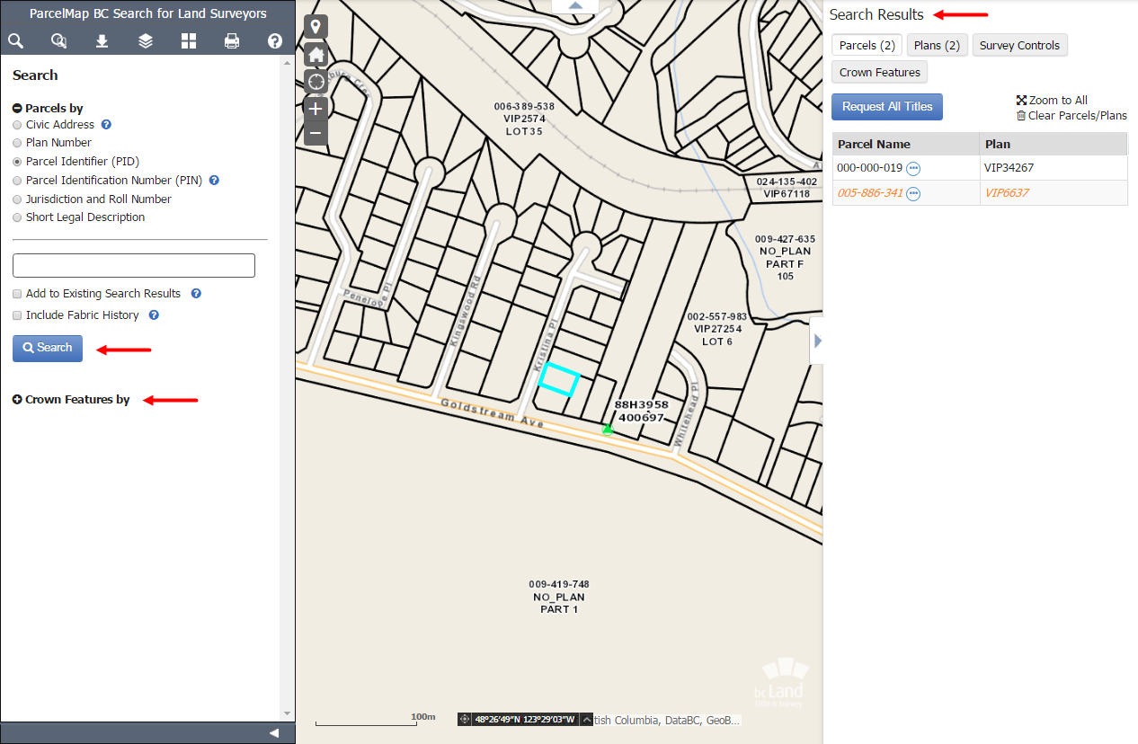
Orange parcels are historical. Click Include Fabric History to show historical parcel representations in your search. Fabric History layer must be checked in Adjust Map Layers for these results to display.
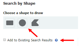
If you wish to conduct a subsequent search to add to your existing results, check Add to Existing Search Results, select the desired search methods, enter the value and click Search. This can be done repeatedly and will continue to build your search results.
Search by Shape
You can search parcels in the parcel fabric by defining a shape based on an area of interest.
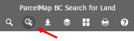
Click the Search by Shape icon
Choose a shape type to draw by clicking a shape icon
Draw a shape on the map with your selected shape option to select the desired parcels as follows:
- Rectangle or Circle: To draw, press down and hold the left mouse button, drag the desired area and let go to finish and highlight parcels on the map
- Polygon: To draw, click the left mouse button at the desired start point, move to the next area of the map and left click to complete the first side of the shape, repeating to define the desired area, using a double click to finish the shape and highlight parcels on the map
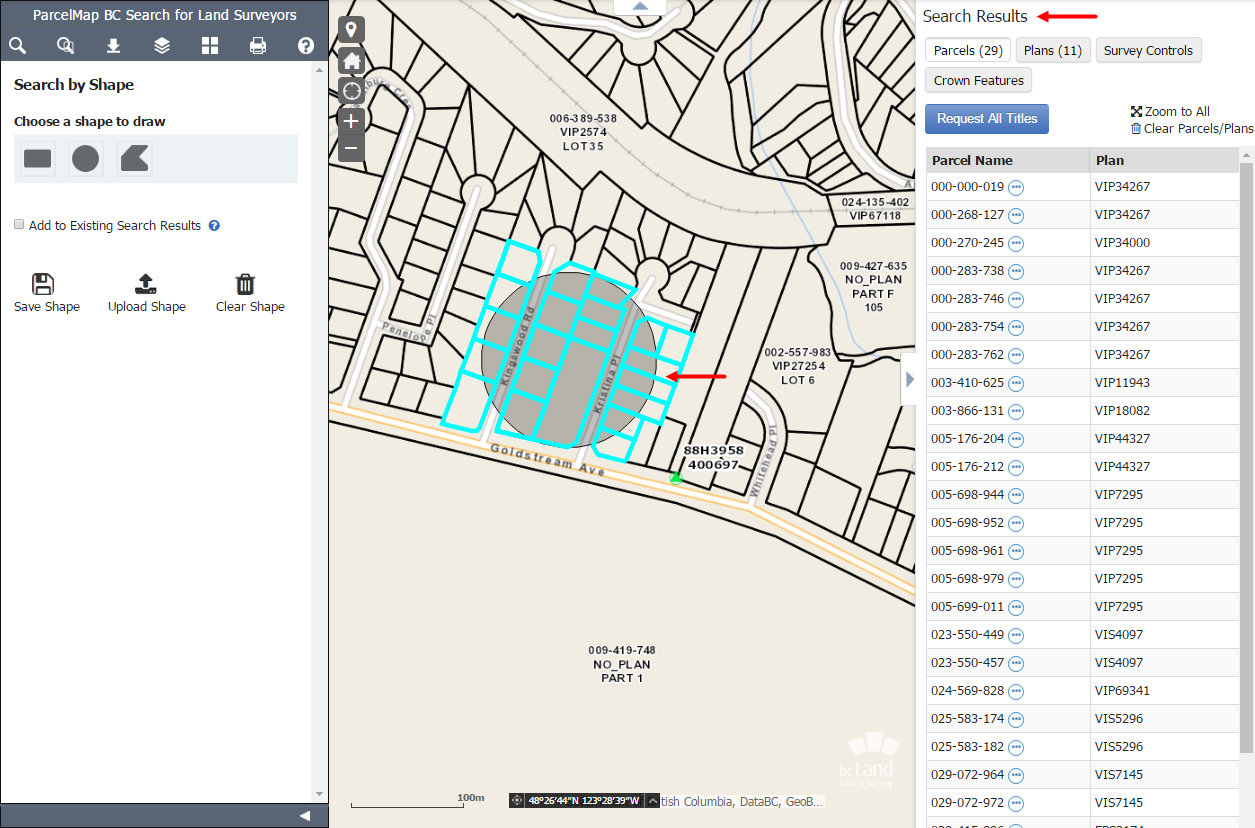
The results will be displayed on the Search Results pane on the right hand side. From the Search Results panel, you can view parcel, survey control, and crown feature details, search titles, order plans, zoom to parcels, clear results and navigate to related services for related information. See Manage Search Results.
Once your shape is drawn, these are the actions you can take with that shape:
- Save Shape: While a shape exists on the map, click Save Shape will allow you to save the shape on your computer
- Upload Shape: While a shape exists on the map, click Upload Shape to upload a previously saved shape on the map. The highlighted parcels will be loaded onto the map and the map will zoom and pan to this location.
- Clear Shape: Click Clear Shape to permanently clear the current shape on the map. It cannot be recovered and must be drawn again.
Only files that had been downloaded from the ParcelMap BC parcel fabric can be uploaded. No other file formats are permitted.
If you wish to conduct a subsequent search to add to your existing results, check Add to Existing Search Results, select the desired search methods, enter the value and click Search. This can be done repeatedly and will continue to build your search results.
In This Section
Introducing an improved ParcelMap BC
An upgraded version of ParcelMap BC has been released featuring a new layout, easier navigation, direct integration with related search services including plan and title applications and access to enhanced map capabilities and features. To learn more about the upgraded version of ParcelMap BC, please see ParcelMap BC New.
The classic version of ParcelMap BC will be available in parallel, until it is retired later this fall. Look for ParcelMap BC classic and ParcelMap BC new in your LTSA account menu options.