To provide transparency into operational planning, the Spatial Improvement Assessment app delivers visual insights into the objective analysis used by the ParcelMap BC Operations team to plan and prioritize spatial improvement work across the province.
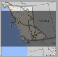
Regularly updated, this app provides a view into the assessed accuracy of the parcel fabric, broadly identifying Assessed Accuracy of the Parcels across the province based on the distance to known control points. The app also highlights Candidate Areas for improvement based on criteria that indicates whether the area is adjustable, as well as previously Adjusted Areas.
Candidate Areas may become Spatial Improvement Areas of Interest or, the targeted candidate areas most in need of improvement. Completed areas are also displayed along with the date of completion and the assigned name.
More information on map navigation and other tools--as well as a description of the map layers available in the app--can be found in the two sections below. Please contact myLTSA Tech Support if you have additional questions or require support for the ParcelMap BC Spatial Improvements Assessment app.
Map Navigation and Tools
| ICON | LABEL | DESCRIPTION |
|---|---|---|

| LEGEND | Displays a legend for the layers currently visible in the map. |

| LAYER LIST | Displays a list of all operational and reference layers in the app and provides the ability to toggle whether the layer is active. Layers listed in lighter text are not visible at the current zoom level. A description of each layer (including a legend) can be found in the Map Layers in the App section below. |

| QUERY AREA of INTEREST by STATUS | Query Area of Interest layer based on the status of the spatial improvement for the defined area. |

| PRIORITY TARGETS QUICK FIND | Spatial bookmarks for quick navigation to identified Priority Target areas for spatial improvement. |

| COMPLETED AREAS QUICK FIND | Spatial bookmarks for quick navigation to areas where spatial improvements have been completed. |

| Advanced or basic printing of the current map. | |

| BASEMAP GALLERY | Presents a gallery of basemaps and allows the user to select one. |

| DRAW | Draws basic graphics and text on the map. |

| ADJUSTMENT READINESS SUMMARY | Summarizes the number of Areas of Interest, Candidate Areas. The layer must be active in the Layer List to be included in the summary. |

| SEARCH | Interactive text-based search for locating and navigating to a location on the map based on multiple sources:
|
|
| ABOUT | Provides information about the app, including access to Help, a list of current Priority Targets, as well as Completed Areas for Spatial Improvements. |
|
| ZOOM IN/OUT | Click to zoom in or out from the current extent. |
|
| HOME | Click to zoom to the map's starting extent. |
|
| MY LOCATION | Detects the user's physical location and zooms to it on the map. |
|
| NEXT / PREVIOUS EXTENT | Allows user to navigate the map to its previous or next extent. |

| COORDINATE | Displays coordinates in the current map projection when moving the pointer on the map, or in other coordinate systems by clicking on the map. |
| OVERVIEW MAP | Shows the current spatial extent of the map display as a gray rectangle relative to the entire spatial extent of the basemap service. |

| APP STATE | Click to restore the map extent and layers' visibility to where the user left off. |
Map Layers in the App
| SPATIAL IMPROVEMENT ASSESSMENT LAYERS | ||
| Spatial Improvement Areas of Interest |

| Areas identified as priority targets for spatial improvement. These include areas that are identified as Targets, In Progress, and Complete. Complete areas will be labelled with the date of completion and an assigned name. This layer is available on ArcGIS Online. |
| Relative Adjustment Vectors |
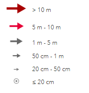
| These features represent the relative magnitude and direction of parcel points to their known control position. This is a relative representation of how parcels may move during a spatial improvement. The class breaks are based on estimated Distance to Control. This layer is available on ArcGIS Online. |
| Candidate Area: |

| These 1km2 hexagons represent candidate areas to consider as targets for spatial improvements based on several factors:
In planning, candidate areas are generally used to help identify Spatial Improvement Areas of Interest. This layer is available on ArcGIS Online. |
| Adjusted Area: |

| These 1km² hexagons represent areas that have previously been adjusted. This layer is available on ArcGIS Online. |
| Assessed Accuracy: 1km2 Hexagons |

| These 1km2 hexagons represent areas of the parcel fabric summarized based on average assessed positional error. This helps identify local trends in fabric accuracy and is based on available information (mainly in areas where there are recent survey plan submissions). In addition, it may over-estimate or under-estimate accuracy in areas with fewer recent survey plans. Undetermined indicates areas of the parcel fabric with no recent data to assess accuracy. Hexagon with a star indicates that at least one or multiple parcel points is 5 metres or more away from its known control position. By zooming in, the Relative Adjustment Vectors will indicate the location of these points. This layer is available on ArcGIS Online. |
| Assessed Accuracy: 20km2 Hexagons |
| These 20km2 hexagons represent areas of the parcel fabric summarized based on average assessed positional error. This helps identify local trends in fabric accuracy and is based on available information (mainly in areas where there are recent survey plan submissions). In addition, it may over-estimate or under-estimate accuracy in areas with fewer recent survey plans. Undetermined indicates areas of the parcel fabric with no recent data to assess accuracy. This layer is available on ArcGIS Online. |
| Parcel Improvements: 20km2 Hexagons |
| These 20km² hexagons outline areas where a significant number of parcels have been adjusted and improved. This layer is available on ArcGIS Online. |
| REFERENCE LAYERS | ||
| Integrated Survey Areas |

| This layer features the mapped representation of Integrated Survey Areas as available on the BC Data Catalogue. |
| ParcelMap BC Parcel Fabric |

| This layer features the Open Government view of the ParcelMap BC parcel fabric, available from the BC Data Catalogue (refreshed weekly). |
| Municipalities |

| This layer features the mapped representation of Municipalities as available on the BC Data Catalogue. |
| Regional Districts |

| This layer features the mapped representation of Regional Districts as available on the BC Data Catalogue. |
Hexagon Attributes
Hexagons are provided at different two different scales: 1 km², 20 km². Visibility of the different sizes is dependant on the zoom scale of the map.
Each hexagon has a unique ID (GRID ID), as well as several other attributes. You can query these attributes by clicking on the centre of the hexagon.

| Field Name | Definition |
| GRID ID | The Hexagon ID |
| Active Controls | Number of Active Control Points |
| Survey Plan Datasets | Number of High Accuracy Survey Plan Datasets |
| Edited | The last date this hexagon was edited in the application |
| Improvement Category: | |
| Not enough controls | The hexagon does not have enough control points to be spatially improved. |
| Adjustable | The hexagon has enough control to be improved; however, the points are within 3m of their true location, indicating that it is not a priority area for spatial improvement. |
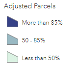
| Candidate for Adjust | The hexagon has enough control to be improved and there are points that are 2m or more away from their true control location. Furthermore, less than 50% of the area has been previously adjusted making this hexagon a good candidate for spatial improvement. |
| Candidate for Re-adjust | Most of the hexagon has been previously adjusted. However, there are still points that are 1m or more away from their true control location. This is a good candidate area for re-adjustment. |
| Adjusted | 85% or more of the hexagon has been previously adjusted. |
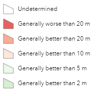
| Parcel Quality: | |
| Undetermined | Areas of the parcel fabric with no recent data to assess accuracy. |
| Generally worse than 20 m | Based on the information we have, this area is not very accurate and is presumed to be worse than 20 m. This may be due to the lack of recent survey data, or large distance to the nearest control point. |
| Generally better than 20 m | Based on the information we have, this area is generally better than 20 m. |
| Generally better than 10 m | Based on the information we have, this area is generally better than 10 m. |
| Generally better than 5 m | Based on the information we have, this area is generally better than 5 m. |
| Generally better than 2 m | Based on the information we have, this area is generally better than 2 m. |
In This Section
Introducing an improved ParcelMap BC
An upgraded version of ParcelMap BC has been released featuring a new layout, easier navigation, direct integration with related search services including plan and title applications and access to enhanced map capabilities and features. To try the upgraded version of ParcelMap BC, please go to ParcelMap BC New.
The classic version of ParcelMap BC will be available in parallel, until it is retired later this fall. Look for ParcelMap BC classic and ParcelMap BC new in your LTSA account menu options.