|
|
Description/Resolution
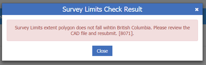
- Users of the Parcel Map Search Service on the LTSA System, rely on the Survey Limits feature submitted through the SPDS CAD file in order to locate plans in the fabric. It also aids surveyors in researching which plans may impact an area where they are going to be doing work.
- As outlined on Page 3-2 of the Survey Plan Dataset Specifications, the Survey Limits feature “should include the lands surveyed (entities within the heavy outline as well as other survey evidence found or set on the plan and resolved boundaries).” Note that this does not include ties to control, unless those control points are contained within the general survey area.
|
|
|
Description/Resolution
- If the Survey Limits feature falls outside the geographical extent of the Province of BC a warning will be displayed.
|
2. Line work on correct layer check
|
|
|
Description/Resolution
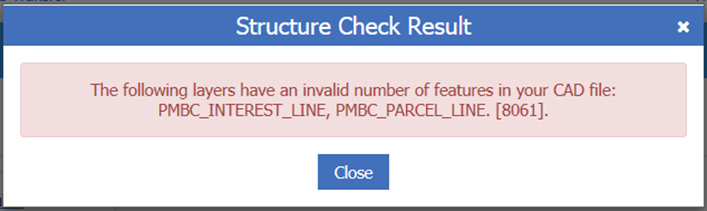
- Features on the PMBC_PARCEL_LINE or PMBC_INTEREST_LINE layers are used by ParcelMap BC to construct Parcel polygons which are used to update the fabric. Any Plan type that is expected to create new parcels should have enough features on one of these two layers to define a closed polygon.
- A minimum of three line segments is required for defining a closed polygon on the PMBC_PARCEL_LINE or PMBC_INTEREST_LINE layers as a workaround to successfully pass the structure validation check.
- Line work on Posting plans do not define new parcel boundaries and should not be placed on either of these layers. They should only be placed on the PMBC_RESOLVED_LINES layer.
If polyline features are used to represent parcel boundaries (instead of individual 2-point lines or arcs), this may be seen as only a single feature, and the same error message may display. This can be resolved by using the EXPLODE command in your CAD application to convert polylines (other than natural boundaries) to 2-point lines.
|
3. Polyline features on tie line layer check
|
|
|
Description/Resolution
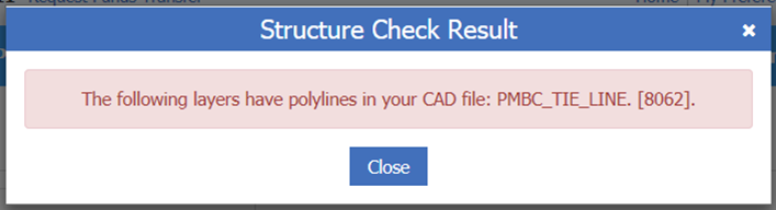
- This structure check ensures that polyline features have not been included within the PMBC_TIE_LINE layer.
|
4. Two-point polyline features on parcel line layer check
|
|
|
Description/Resolution
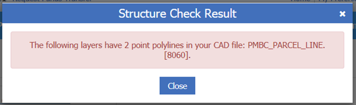
- The ParcelMap BC system is only able to calculate bearings and distances for two point lines or arcs; if a polyline feature is used, no dimensions get generated.
- Polylines should be used only to represent natural boundaries, please see Table 3-1 of the Survey Plan Dataset Specifications and Table 1 of the Tips and Tricks for Survey Plan Dataset Creation outlining the types of features permissible to include on the PMBC_TIE_LINE layer.
- Two-point polylines can be easily converted to simple lines and arcs by selecting them and running the EXPLODE command in your CAD application.
|
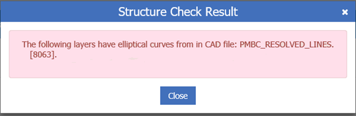
5. Elliptical curves in CAD file check
|
|
|
Description/Resolution
- This structure check ensures that the CAD file contains no elliptical curves.
- The survey plan dataset cannot be submitted until the elliptical curves are replaced by simple (“true”) curves.
|
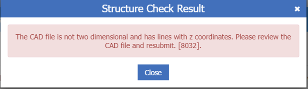
6. Features with "Z" values check
|
|
|
Description/Resolution
- The survey plan dataset “Z” values check ensues that there are no linear features submitted with elevation values.
- ParcelMap BC does not support features with Z values since it is a 2D cadastre.
- Use the Flatten command to force all linear features to have no elevation values.
|
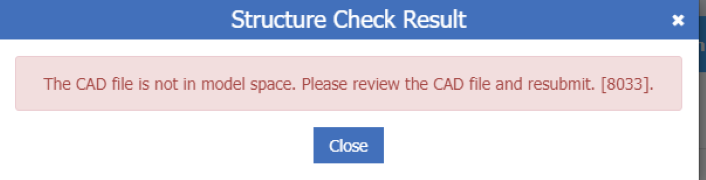
7. Dataset not in model space check
|
|
|
Description/Resolution
- Entities appearing in Layout tabs must not be placed on any of the PMBC layers or you will receive a PMBC structure check error.
|
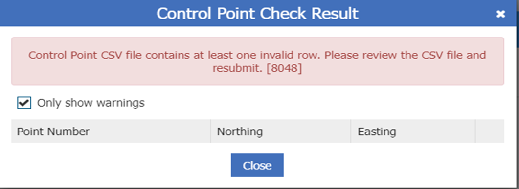
8. Control point CSV file check
|
|
|
Description/Resolution
- The control point check ensures that the CSV file is correctly formatted.
- If you encounter a validation error, it is recommended to open the CSV file in a text editor.
- Please see Optimizing the Survey Data Control Point File for reference.
|
9. Topology check
|
|
|
|
|
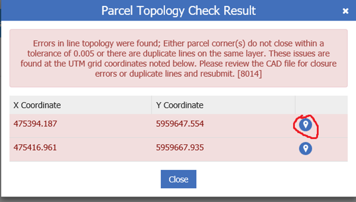
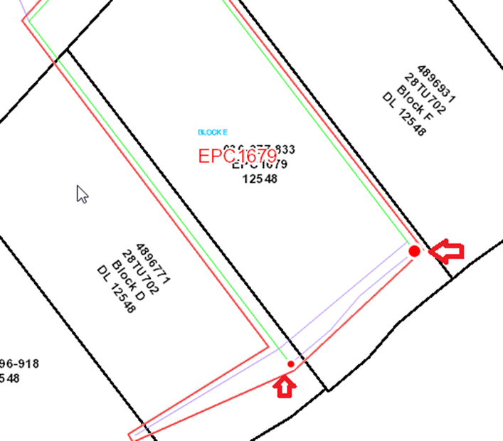
Description/Resolution
- The survey plan dataset topology check ensures that the CAD files contain valid, closed polygons.
- The survey plan dataset cannot be submitted until the topology errors have been corrected.
- When an error has been flagged, the validation window will show “Locate by symbols” that when clicked, will launch the map check window and highlight red circles to allow the user to locate and correct the topology errors. In this example the parcel boundary (in green) is unclosed
|
10. Average combined scale factor check
|
|
|
Description/Resolution
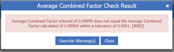
- This check ensures that SPDS CAD files have been appropriately scaled to meet ParcelMap BC requirements. This is calculated from the coordinates of any control points supplied, along with an approximate elevation derived from a Digital Elevation Model.
- The computed value is an estimate and is intended only as a check against accidental errors when entering the CSF into your Survey Plan Submission metadata form (such as transposed numbers or entry of a grid-to-ground direction factor when a ground-to-grid factor is expected).
- This warning can be overridden, if the entered value is consistent with the combined scale factors listed in the plan.
|
For additional tips and tricks in preparing Survey Plan Datasets for submission, please see: Tips and Tricks for Survey Plan Dataset Creation
|