
You may access the survey plan datasets you have submitted as well as those submitted by your organization.
As communicated through recent notices, new survey plan datasets should now be submitted through the current Surveyhub process where applicable. If you need assistance regarding a legacy plan or dataset submission, please email LTSA technical support.
From any page of the LTSA's Electronic Services, rollover Submissions in the navigation bar at the top of the page and click Survey Plan Dataset
A list of survey plan datasets will now appear
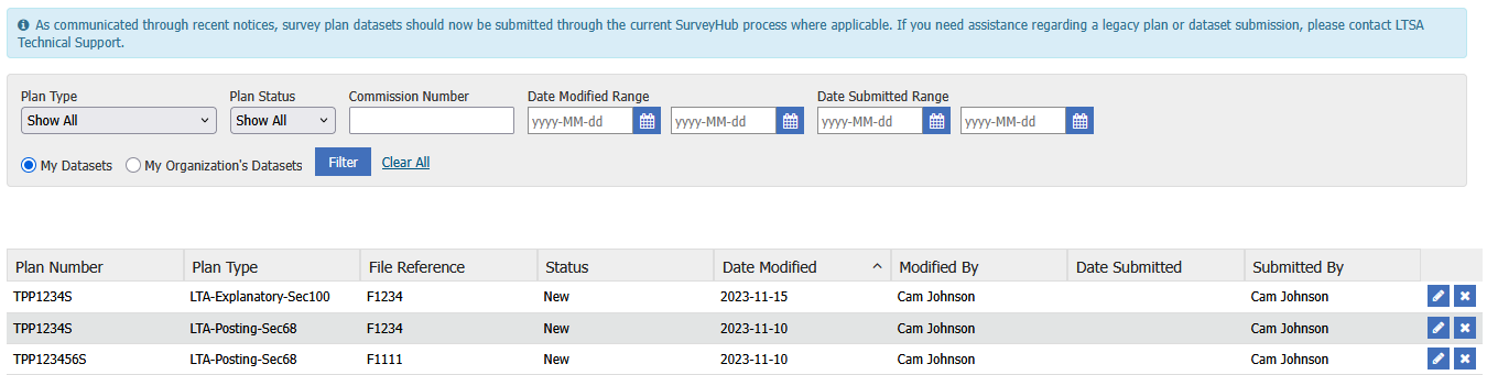
By default, your datasets are displayed. Filter by My Organization's Datasets to view your organization's datasets.
From this page, you are able to search datasets by Plan Type, Plan Status, Date Modified Range and Date Submitted Range
The status of your survey plan datasets will show as: New, Pending, Submitted or Published
Labelled New and Submitted survey plan datasets can be edited or deleted. Pending and Published survey plan datasets are read only and cannot be edited or deleted.
Click the icon to the far right on the row of the survey plan dataset you wish to edit, delete or view
- To view your survey plan datasets, click the magnifying glass icon. Only Survey Plan Datasets which have a Pending or Published status can be viewed and are not editable.

- To edit your survey plan datasets, click the Pencil icon. Only survey plan datasets which have a New or Submitted status can be edited.

- To delete your survey plan datasets, click on the X icon. Only survey plan datasets which have a New or Submitted status can be edited.

As communicated through recent notices, survey plan datasets are now submitted through the current Surveyhub process where applicable. If a survey plan dataset is deleted through the above process, the option to create a new dataset would only be through Surveyhub.
Plan Information that can be edited for an Survey Plan Dataset includes the following:
- Plan Type: Choose the type of plan being submitted. Changing this field will require performing validation again, if it has already been done.
- Plan Number: Enter the CLR or LTR number of the plan. Changing this field will require performing validation again, if it has already been done.
- Control Number: Enter the Control Number of the associated plan number. Please note, this control should match the control number shown on the Survey Plan Certification PDF during plan registration.
- Commission Number: Enter the Commission Number of the land surveyor who digitally signed the plan. Changing this field will require performing validation again, if it has already been done.
- Survey Date: Choose the survey completion date. This field must be set to a date before the current date.
When submitting an LTA Posting Plan via the LTSA survey plan submission dashboard, please ensure you select the correct Land Title Act from the drop down menu. When incorrectly selecting the Land Act plan type, the drop will display a Land Act Posting plan type.
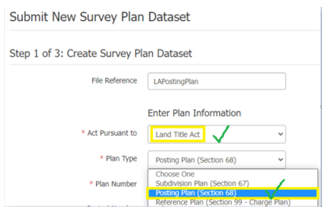
Dataset Properties that can be edited on a plan include:
- UTM Zone: Choose the Universal Transverse Mercator map projection zone number. This field is used when displaying a survey plan dataset on the map for validation. Changing this field will require performing the map check again, if it has already been done.
- Georeference Method: Choose the method used to georeference the plan.
- Dimension Annotation In: This identifies whether the dimension annotations in the DWG file submitted are UTM grid distances or are ground distances.
- Average Combined Factor: This field must be a number between 0.9 and 1.1 and should always be given in the ground-to-grid direction .
- Additional Combined Factor: Enter other combined factors used in the plan, if more than one is used. This field must be a number between 0.9 and 1.1, and multiple values may be entered.
- Relative Survey Accuracy: This describes the relative accuracy of the survey as assessed by the surveyor. This value is used by the ESRI parcel editor to weight the submitted dataset when performing a least squares adjustment of the fabric. (See PMBC Survey Plan Dataset Specification page 3-11 for more information). For the majority of datasets submitted the default value of 3 should normally remain unchanged unless there is a specific reason to change it.
- Datum and Version: Choose the Datum and Version (epoch) used to georeference the plan.
- Comments: Enter any additional comments that should be attached to the survey plan dataset.
- Upload Survey Data CAD File: Click Browse and navigate to where the Survey Data CAD file is located. The CAD file contains the survey information. Upon selecting this file, the system will attempt to upload the file. After the upload has completed you may remove the file by clicking the "X" icon that appears, or you may select a new file by clicking Browse again. Changing this field will require performing validation again, if it has already been done.
- Upload Survey Control Point CSV File: Click Browse and navigate to the location of where the Survey Control Point CSV file is located. The CSV file contains the control points for the survey plan dataset. Upon selecting this file, the system will attempt to upload the file. After the upload has completed, you may remove the file by clicking the ‘X' icon that appears, or you may select a new file by clicking Browse again. Changing this field will require performing validation again, if it has already been done.
View Survey Data CAD and Survey Control Point CSV requirements
Clicking Save Dataset allows you to save the survey plan data set once all required fields have been populated. Any changes to the survey plan dataset are required to be saved in order for the changes to be kept. The Validate Dataset and Perform Map Check buttons are only available if the survey plan dataset has all required attributes and files and is saved. The button becomes a link if the validation checks have been already run.
The final step once the dataset has been created with all required files and attributes and undergoes a successful validation will be to submit it. Click the checkbox beside "I am certifying that this dataset was prepared in accordance with the requirements of Surveyor General Practice Bulletin No. 3 and then click Submit Dataset
- This button allows a commissioned BC land surveyor to declare a survey plan dataset as ready to be published
- To enable this button the checkbox must be selected indicating the land surveyor is certifying this survey plan dataset
